


J7A OULED-MARRAK

bikeup
User
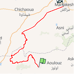

Length
293 km

Max alt
2696 m

Uphill gradient
10104 m
Km-Effort
428 km

Min alt
421 m

Downhill gradient
10147 m
Boucle
No
Creation date :
2014-12-10 00:00:00.0
Updated on :
2014-12-10 00:00:00.0
7h40
Difficulty : Unknown

FREE GPS app for hiking
 SityTrail
IGN / Geographical institutes
SityTrail World
The world is yours!
About
Trail Other activity of 293 km to be discovered at Souss-Massa, Pachalik d'Oulad Berhil, Oulad Berhil. This trail is proposed by bikeup.
Positioning
Country:
Morocco
Region :
Souss-Massa
Department/Province :
Pachalik d'Oulad Berhil
Municipality :
Oulad Berhil
Location:
Unknown
Start:(Dec)
Start:(UTM)
550282 ; 3389876 (29R) N.
Comments
Trails nearby